BSW Temple commute guide
Neighborhoods Near Baylor Scott & White Temple by Commute
Estimated without traffic, the Hospital District is about 2 minutes from BSW Temple’s main entrance, followed by Canyon Ridge (about 5) and South Pointe, Canyon Creek and Prairie Ridge (about 6 minutes). Compare all 19 neighborhoods by drive estimate, asking price and shift tradeoffs, then check the route to your own building and parking lot.
Incoming resident or fellow? Start here · BSW relocation hub
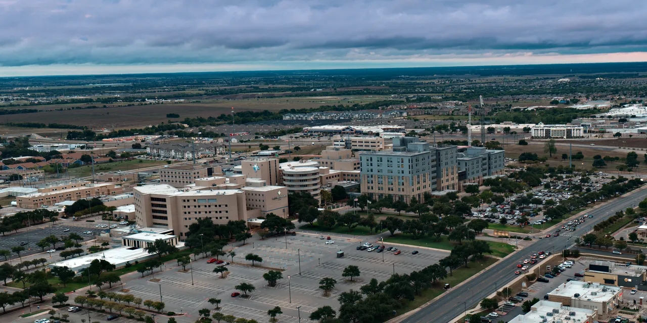
Baylor Scott & White Medical Center – Temple, looking south along South 31st Street · Drone photo by Taylor Dasch, October 3, 2026
At a glance
Which Temple neighborhoods are closest to Baylor Scott & White by drive time?
Estimated without traffic to the hospital’s main entrance at 2401 S 31st St, the shortest drive is from the Hospital District at about 2 minutes, then Canyon Ridge (about 5) and South Pointe, Canyon Creek and Prairie Ridge (about 6 minutes). Most of the other neighborhoods here land between 8 and 13 minutes, while Lake Pointe, Groves at Lakewood Ranch, Carriage House Trails, Three Creeks and Dawson Ranch run about 15 to 21. Rush hour adds time these estimates leave out, and so do parking and walking, and your building may not be the main hospital.
How to use it: shortlist two or three neighborhoods by estimated drive and price, then drive each route at your actual shift hour before you make an offer.
- 5neighborhoods about 7 minutes or less from the main entrance, without traffic
- 2 of 31Temple public rail grade crossings with a 24-hour whistle ban (FRA inventory)
- 228Temple listings under $250K with 2+ bedrooms on Sep 30, 2026 (median $213K)
- $1,625median asking rent for a 3-bedroom rental in Temple (n=48, Sep 23, 2026)
The comparison
How long is the drive from each neighborhood to BSW Temple?
All 19 neighborhoods, estimated the same way. Each route starts at the middle of the neighborhood’s platted lots and ends at the hospital’s main entrance at 2401 S 31st St. Two OpenStreetMap-based routing engines estimate the drive without traffic; the figure is their average and the range shows where they differ. Prices are active asking prices, not sale prices.
| # | Neighborhood | Drive estimate, no traffic | Miles | Nearest rail crossing | Active asking prices | School district | Route and checks |
|---|---|---|---|---|---|---|---|
| About 7 min or less | |||||||
| 1 | Hospital DistrictTemple | 2 min | 0.6 | 0.85 mi | $120K–$245Kmedian $162K · n=25 within 1 mile of the campus | Temple ISD | Older streets beside the campus. Taylor’s video describes 1950s–60s pier-and-beam homes, so plan on an inspection. Next door to a Level I trauma center’s emergency traffic; nearest public rail crossing 0.85 mi. |
| 2 | Canyon RidgeTemple | 5 minrange 5–6 min | 2.1 | 0.85 mi | $245K–$352Kmedian $326K · n=6 | Temple ISD | Surface streets via Marlandwood Rd and S 31st St. Active listings were built 2007–2018. Taylor lives here; see the disclosure below. |
| 3 | South PointeTemple | 6 minrange 5–6 min | 2.8 | 1.14 mi | $220K–$284Kmedian $260K · n=6 | Temple ISD | Via the southeast Loop 363 and S 31st St. Nearest public crossing (FM 3117) is 1.14 mi away; the railroad reports about 12 daytime and 12 nighttime through trains there. |
| 4 | Canyon CreekTemple | 6 minrange 5–7 min | 2.0 | 1.67 mi | $199.9K–$270Kmedian $237K · n=10 | Temple ISD | Surface streets to S 31st St. Prices are the standard phases; Cliffs of Canyon Creek lists separately (7 active, $232K–$499K). |
| 5 | Prairie RidgeTemple | 6 min | 2.9 | 0.60 mi | $187K–$290Kmedian $238K · n=14 | Temple ISD | Via the southeast Loop 363 and S 31st St. The $187K low is a 1-bedroom build; 2+ bedroom listings start at $210K. Nearest public rail crossing 0.60 mi. |
| About 8–10 min | |||||||
| 6 | Legacy RanchTemple | 8 min | 3.6 | 2.04 mi | 1 activeToo few listings to show a range | Belton ISD | Only 1 active listing on the Sep 30, 2026 snapshot. Belton ISD on 14 of 15 MLS records (that listing plus closed sales Aug 21, 2025–Sep 30, 2026). |
| 7 | Wyndham HillTemple | 8 minrange 7–9 min | 3.4 | 0.76 mi | $237K–$309Kmedian $290K · n=10 | Academy ISD | Via Waters Dairy Rd, Hartrick Bluff Rd and S 31st St. Academy ISD in MLS; nearest public rail crossing 0.76 mi (Union Pacific). |
| 8 | Historic DistrictTemple | 8 minrange 7–10 min | 3.2 | 0.79 mi | No MLS-defined area; price by property | Check by address | Route via N 9th St, W Adams Ave and N 31st St. No MLS-defined area, so no price is shown. The City’s district map shows rail tracks along its western edge. |
| 9 | Bella TerraTemple | 9 minrange 8–9 min | 3.8 | 2.36 mi | $335K–$579Kmedian $444K · n=12 | Split: Temple / Belton ISD | Via S 31st St. MLS lists both Temple ISD and Belton ISD addresses here, sometimes on the same street, so check each address. |
| 10 | Western HillsTemple | 9 minrange 8–11 min | 3.7 | 1.00 mi | $199K–$455Kmedian $249K · n=15 | Temple ISD | Via W Adams Ave (FM 2305) and S 31st St. The two engines pick different routes here (8–11 min). MLS shows “None” for HOA on all 15 Western Hills listings active on Sep 30, 2026 (agent-entered). |
| About 11–14 min | |||||||
| 11 | The HomesteadTemple | 12 minrange 11–13 min | 6.7 | 1.08 mi | $340K–$478Kmedian $389K · n=10 | Academy ISD | New construction from more than one builder south of FM 93 (Cotton Bottom Estates plat); the price row includes all of them. Via Old Hwy 95 and the southeast Loop 363. Academy ISD in MLS. |
| 12 | Sage MeadowsTemple | 13 minrange 12–13 min | 6.7 | 2.73 mi | $222K–$363Kmedian $255K · n=7 | Belton ISD | Temple address, Belton ISD in MLS. Via W Adams Ave (FM 2305) and Loop 363. |
| 13 | Hartrick RanchTemple | 13 minrange 10–15 min | 5.4 | 1.59 mi | $255K–$303Kmedian $280K · n=9 | Academy ISD | Via Hartrick Bluff Rd, Waters Dairy Rd and S 31st St. The two engines disagree most here (10–15 min), so drive it at your hour. Academy ISD in MLS. |
| 14 | Hills of WestwoodTemple | 13 minrange 13–14 min | 6.9 | 1.84 mi | $249.9K–$460Kmedian $340K · n=26 | Belton ISD | Via W Adams Ave (FM 2305), the Temple Outer Loop and Loop 363. |
| About 15 min or more | |||||||
| 15 | Lake PointeTemple | 15 min | 7.4 | 3.53 mi | $220K–$365Kmedian $287K · n=20 | Mostly Belton ISD | Via Airport Rd (TX 36), Prairie View Rd, the Temple Outer Loop and S 31st St. Mostly Belton ISD in MLS (74 of 79 records: active listings on Sep 30, 2026 plus closed sales Aug 21, 2025–Sep 30, 2026); nearest public rail crossing 3.53 mi. |
| 16 | Groves at Lakewood RanchTemple | 16 minrange 15–16 min | 8.2 | 3.79 mi | $299.9K–$425Kmedian $375K · n=12 | Belton ISD | Via W Adams Ave (FM 2305) and Loop 363. |
| 17 | Carriage House TrailsTemple | 17 minrange 16–17 min | 6.7 | 1.90 mi | $268K–$355Kmedian $320K · n=7 | Belton ISD | Via Riverside Trail, Poison Oak Rd, Midway Dr (FM 817) and the southwest Loop 363. |
| 18 | Three CreeksBelton | 20 minrange 19–21 min | 13.0 | 3.89 mi | $242K–$499.9Kmedian $345K · n=37 | Belton ISD | Belton. Via Stillhouse Hollow Dam Rd (FM 1670), I-14/US 190 and I-35 to the southwest Loop 363, the I-35 stretch where TxDOT’s planned widening has letting estimated for 2031. |
| 19 | Dawson RanchBelton | 21 min | 9.5 | 0.55 mi | $275K–$499.5Kmedian $359K · n=4 | Belton ISD | Belton. Via Lake Rd (FM 439), Midway Dr and Charter Oak Dr (FM 817). Nearest public crossing (N Wheat Rd, BNSF) is 0.55 mi away. |
- 1. Hospital District2min
- 0.6miles
- 2min range
- 0.85mi to rail crossing
Asking (active)$120K–$245K · med $162K · n=25School districtTemple ISDRoute and checks
Older streets beside the campus. Taylor’s video describes 1950s–60s pier-and-beam homes, so plan on an inspection. Next door to a Level I trauma center’s emergency traffic; nearest public rail crossing 0.85 mi.
- 2. Canyon Ridge5min
- 2.1miles
- 5–6min range
- 0.85mi to rail crossing
Asking (active)$245K–$352K · med $326K · n=6School districtTemple ISDRoute and checks
Surface streets via Marlandwood Rd and S 31st St. Active listings were built 2007–2018. Taylor lives here; see the disclosure below.
- 3. South Pointe6min
- 2.8miles
- 5–6min range
- 1.14mi to rail crossing
Asking (active)$220K–$284K · med $260K · n=6School districtTemple ISDRoute and checks
Via the southeast Loop 363 and S 31st St. Nearest public crossing (FM 3117) is 1.14 mi away; the railroad reports about 12 daytime and 12 nighttime through trains there.
- 4. Canyon Creek6min
- 2.0miles
- 5–7min range
- 1.67mi to rail crossing
Asking (active)$199.9K–$270K · med $237K · n=10School districtTemple ISDRoute and checks
Surface streets to S 31st St. Prices are the standard phases; Cliffs of Canyon Creek lists separately (7 active, $232K–$499K).
- 5. Prairie Ridge6min
- 2.9miles
- 6min range
- 0.60mi to rail crossing
Asking (active)$187K–$290K · med $238K · n=14School districtTemple ISDRoute and checks
Via the southeast Loop 363 and S 31st St. The $187K low is a 1-bedroom build; 2+ bedroom listings start at $210K. Nearest public rail crossing 0.60 mi.
- 6. Legacy Ranch8min
- 3.6miles
- 8min range
- 2.04mi to rail crossing
Asking (active)1 listingSchool districtBelton ISDRoute and checks
Only 1 active listing on the Sep 30, 2026 snapshot. Belton ISD on 14 of 15 MLS records (that listing plus closed sales Aug 21, 2025–Sep 30, 2026).
- 7. Wyndham Hill8min
- 3.4miles
- 7–9min range
- 0.76mi to rail crossing
Asking (active)$237K–$309K · med $290K · n=10School districtAcademy ISDRoute and checks
Via Waters Dairy Rd, Hartrick Bluff Rd and S 31st St. Academy ISD in MLS; nearest public rail crossing 0.76 mi (Union Pacific).
- 8. Historic District8min
- 3.2miles
- 7–10min range
- 0.79mi to rail crossing
Asking (active)Price by propertySchool districtCheck by addressRoute and checks
Route via N 9th St, W Adams Ave and N 31st St. No MLS-defined area, so no price is shown. The City’s district map shows rail tracks along its western edge.
- 9. Bella Terra9min
- 3.8miles
- 8–9min range
- 2.36mi to rail crossing
Asking (active)$335K–$579K · med $444K · n=12School districtSplit: Temple / Belton ISDRoute and checks
Via S 31st St. MLS lists both Temple ISD and Belton ISD addresses here, sometimes on the same street, so check each address.
- 10. Western Hills9min
- 3.7miles
- 8–11min range
- 1.00mi to rail crossing
Asking (active)$199K–$455K · med $249K · n=15School districtTemple ISDRoute and checks
Via W Adams Ave (FM 2305) and S 31st St. The two engines pick different routes here (8–11 min). MLS shows “None” for HOA on all 15 Western Hills listings active on Sep 30, 2026 (agent-entered).
- 11. The Homestead12min
- 6.7miles
- 11–13min range
- 1.08mi to rail crossing
Asking (active)$340K–$478K · med $389K · n=10School districtAcademy ISDRoute and checks
New construction from more than one builder south of FM 93 (Cotton Bottom Estates plat); the price row includes all of them. Via Old Hwy 95 and the southeast Loop 363. Academy ISD in MLS.
- 12. Sage Meadows13min
- 6.7miles
- 12–13min range
- 2.73mi to rail crossing
Asking (active)$222K–$363K · med $255K · n=7School districtBelton ISDRoute and checks
Temple address, Belton ISD in MLS. Via W Adams Ave (FM 2305) and Loop 363.
- 13. Hartrick Ranch13min
- 5.4miles
- 10–15min range
- 1.59mi to rail crossing
Asking (active)$255K–$303K · med $280K · n=9School districtAcademy ISDRoute and checks
Via Hartrick Bluff Rd, Waters Dairy Rd and S 31st St. The two engines disagree most here (10–15 min), so drive it at your hour. Academy ISD in MLS.
- 14. Hills of Westwood13min
- 6.9miles
- 13–14min range
- 1.84mi to rail crossing
Asking (active)$249.9K–$460K · med $340K · n=26School districtBelton ISDRoute and checks
Via W Adams Ave (FM 2305), the Temple Outer Loop and Loop 363.
- 15. Lake Pointe15min
- 7.4miles
- 15min range
- 3.53mi to rail crossing
Asking (active)$220K–$365K · med $287K · n=20School districtMostly Belton ISDRoute and checks
Via Airport Rd (TX 36), Prairie View Rd, the Temple Outer Loop and S 31st St. Mostly Belton ISD in MLS (74 of 79 records: active listings on Sep 30, 2026 plus closed sales Aug 21, 2025–Sep 30, 2026); nearest public rail crossing 3.53 mi.
- 16. Groves at Lakewood Ranch16min
- 8.2miles
- 15–16min range
- 3.79mi to rail crossing
Asking (active)$299.9K–$425K · med $375K · n=12School districtBelton ISDRoute and checks
Via W Adams Ave (FM 2305) and Loop 363.
- 17. Carriage House Trails17min
- 6.7miles
- 16–17min range
- 1.90mi to rail crossing
Asking (active)$268K–$355K · med $320K · n=7School districtBelton ISDRoute and checks
Via Riverside Trail, Poison Oak Rd, Midway Dr (FM 817) and the southwest Loop 363.
- 18. Three Creeks20min
- 13.0miles
- 19–21min range
- 3.89mi to rail crossing
Asking (active)$242K–$499.9K · med $345K · n=37School districtBelton ISDRoute and checks
Belton. Via Stillhouse Hollow Dam Rd (FM 1670), I-14/US 190 and I-35 to the southwest Loop 363, the I-35 stretch where TxDOT’s planned widening has letting estimated for 2031.
- 19. Dawson Ranch21min
- 9.5miles
- 21min range
- 0.55mi to rail crossing
Asking (active)$275K–$499.5K · med $359K · n=4School districtBelton ISDRoute and checks
Belton. Via Lake Rd (FM 439), Midway Dr and Charter Oak Dr (FM 817). Nearest public crossing (N Wheat Rd, BNSF) is 0.55 mi away.
Drive estimates: OSRM and Valhalla on OpenStreetMap data, no traffic, requested Oct 4, 2026; the figure is their average, the range their spread, and miles are the OSRM route drawn on the map. [1][2] Prices: CTXMLS active listings on Sep 30, 2026; n = active listings, and rows with fewer than 3 show the count only. Hospital District prices are active listings within 1 straight-line mile of the hospital. [3] School district: the MLS-listed district (agent-entered); confirm any address with the district. [5] Rail: straight-line distance to the nearest open public at-grade crossing in the FRA inventory (Bell County and its adjacent counties). [9]
Want three of these narrowed to your shift and price range? Taylor compares the routes and current listings for your situation. Request a shortlist.
Map and method
Where do the routes to BSW run, and how were these times estimated?
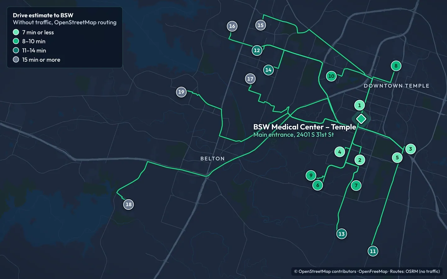
How the drive times were estimated
- Start point
- The middle of each neighborhood’s platted lots: the median of Bell County Appraisal District parcel centers. Hospital District uses lots within 1 mile of the hospital; Historic District starts at N 9th St and W King Ave. [2]
- Destination
- The hospital’s main entrance at 2401 S 31st St (the drive off Scott Boulevard, reached from South 31st Street).
- Engines
- OSRM (car profile) and Valhalla (auto costing), both running on OpenStreetMap data on public servers, requested October 4, 2026. Neither models live or historical traffic. [1]
- How it is shown
- The figure is the average of the two estimates, rounded to the minute; the range shows their spread. Miles are the OSRM route, the line drawn on the map. For several neighborhoods Valhalla chose a different, longer route of similar time.
- Checked
- Requested October 4, 2026, and re-run at each review of this page.
- Not included
- Traffic, parking, walking, shuttles, weather, crashes, school buses and short-term closures.
Map estimate
What this page publishes: a routing engine’s estimate of the drive on empty roads, averaged across two engines. Reproducible, but it is a model, not a drive someone timed.
Observed drive
A trip actually driven and timed on a stated date. One observed drive is a sample of one: weather, a crash or a school bus can move it by several minutes.
Door-to-department time
The drive plus parking, walking and any shuttle between your lot and your unit. This is the number that decides when you leave home, and only your assignment can answer it.
Before you trust a number
What does a drive-time number leave out?
A map estimate answers one question: how long the roads take when they are empty. These checks cover what it cannot.
Parking and walking
BSW’s onboarding page says employees at most locations need a parking decal, and that Temple badges and parking assignments come from the badging office in Building 17, Room 125 (Monday–Friday, 7:30 a.m.–4:30 p.m.). BSW’s campus shuttle maps show a Blue route running 6:30 a.m.–5:30 p.m. and Yellow and Pink routes running 6:30 a.m.–2:30 p.m., so an early or late shift can fall outside shuttle hours. [6]
BSW runs more than one Temple building; McLane Children’s Medical Center, for example, is at 1901 SW H K Dodgen Loop, not the main hospital address. [7]
Before you choose a street: ask your department or onboarding contact which lot you will use and how long the walk or shuttle takes, then add it to the estimate in the table.
Rush hour and shift times
These estimates assume empty roads. The Killeen-Temple MPO measures congestion as peak-hour travel time against free-flow time for a 6–9 a.m. morning peak and a 4–7 p.m. evening peak, so a 7 a.m. shift start, a 5 p.m. drive home and a night shift’s drive home after 7 a.m. all fall inside them. Its 2023 update rated I-35 through Temple, from South to North Loop 363, uncongested: in 2021, peak trips there took about 1% longer than at free flow (travel time index 1.01). It does not report Loop 363 or neighborhood streets. [12]
Routes that stay on surface streets, without Loop 363 or an interstate: Hospital District, Canyon Ridge, Canyon Creek, Legacy Ranch, Wyndham Hill, Historic District, Bella Terra, Western Hills, Hartrick Ranch and Lake Pointe. The rest use Loop 363, I-35 or I-14 for part of the drive. Drive your route at your own hours before you choose.
Construction
TxDOT’s project data, checked October 4, 2026, lists no active construction on West Adams Avenue (FM 2305); its next listed project, a rehabilitation from SH 317 west, has letting estimated for 2029. The same data still shows seal-coat and maintenance work let in 2024 on FM 1670 and I-14 near Belton, which the Three Creeks route uses, as under construction, and the I-35 widening between Belton and South Loop 363 in engineering with letting estimated for 2031. The City of Temple’s Outer Loop page lists North Outer Loop work on Old Howard and Moores Mill roads in north Temple, off these routes, and gives no current status for its West Outer Loop phases. [8]
Map estimates do not reflect short-term lane closures, so check current notices before you rely on a route.
Noise and sleep
Federal rules require a locomotive horn when a train approaches a public grade crossing, and only two Temple crossings, South Main and South 8th streets, carry a 24-hour whistle ban. The crossing distances on this page are straight-line measurements from each neighborhood’s center, not noise readings. [9]
Within 1 mile of a public crossing (straight line from the neighborhood’s center): Dawson Ranch (0.55 mi), Prairie Ridge (0.60 mi), Wyndham Hill (0.76 mi), Historic District (0.79 mi), Hospital District (0.85 mi), Canyon Ridge (0.85 mi) and Western Hills (1.00 mi). If you sleep during the day, visit the street at your sleep hours before making an offer; rail, highway, school and campus traffic are property-specific.
School district
A Temple mailing address does not decide the school district. Confirm any address with the district’s own lookup: Belton ISD and Temple ISD publish address lookups, and Academy ISD says residency questions should be confirmed with the Bell County Tax Office. [5]
The district column in the table is the MLS-listed district, which agents enter by hand; one Wyndham Hill listing active on Sep 30, 2026, for example, was entered as Temple ISD for an Academy ISD parcel.
Fair housing: this page does not rank schools or recommend neighborhoods by household type. Districts appear only so you can confirm which one serves an address.
Fatigue
A shorter commute reduces travel time, but it does not make driving while fatigued safe. NHTSA calls adequate daily sleep the only true protection against drowsy driving. When you are too tired to drive, arrange another way home. BSW Temple’s July 2021 house staff handbook, the latest edition we could read, offered residents a call-room suite and taxi or ride-share reimbursement after call; confirm the current policy with your program. [10]
Closest homes
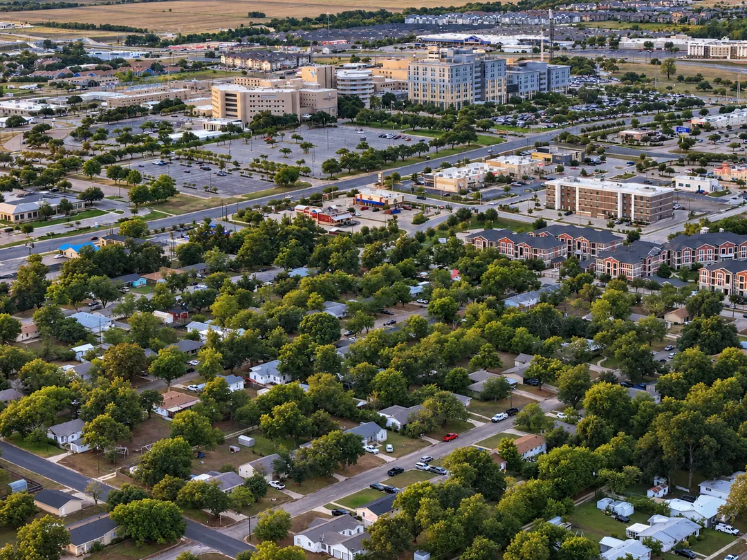
The closest homes: the blocks around the campus
The Hospital District is an area label, not one subdivision: older streets beside the campus, about 2 minutes from the main entrance without traffic. On the September 30, 2026 snapshot, 25 homes were listed within 1 straight-line mile of the hospital, from $120K to $245K (median $162K), all Temple ISD in MLS. [3]
“The caveat to that is that these homes are … 1950s, 1960s builds, pier and beam. So you have to make sure that you get an inspection before you actually go through with purchasing the property.”
Taylor Dasch, on the Hospital District, in his February 2026 BSW neighborhood video [11]
- 2 minto the main entrance, no traffic
- 25active listings within 1 mile, Sep 30, 2026
- $162Kmedian asking price
The Hospital District guide covers the streets, prices and inspection checks in detail.
Your schedule, your shortlist
Which neighborhoods fit your shift pattern and price range?
The same estimates, sorted for the schedule you work or the roads you prefer. Each list is ordered by estimated minutes, not by who should live where.
Night shift or on call
Shortest drives
If you drive home after nights or get called in, the shortest estimates matter most:
- Hospital District2 min
- Canyon Ridge5 min
- South Pointe6 min
- Canyon Creek6 min
Sleeping during the day
Short drive, crossing over 1.5 mi
Shortest estimates among neighborhoods more than 1.5 miles from a public rail crossing:
- Canyon Creek6 min · 1.7 mi
- Legacy Ranch8 min · 2.0 mi
- Bella Terra9 min · 2.4 mi
- Sage Meadows13 min · 2.7 mi
Prefer local streets
No Loop 363 or interstate
Routes that stay off Loop 363 and the interstates, by estimate. Whether that saves time at your hour is untested, so time both kinds of route at shift change:
- Hospital District2 min
- Canyon Ridge5 min
- Canyon Creek6 min
- Legacy Ranch8 min
7-on/7-off · fewer drives
Fewer, longer drives
Driving fewer days can make a longer route a fair trade for more space or a lower price:
- Lake Pointe15 min
- Groves at Lakewood Ranch16 min
- Carriage House Trails17 min
- Three Creeks20 min
- Dawson Ranch21 min
Median asking under $250K
Hospital District ($162K, 2 min), Canyon Creek ($237K, 6 min), Prairie Ridge ($238K, 6 min) and Western Hills ($249K, 9 min).
Median asking $250K–$349K
Sage Meadows ($255K, 13 min), South Pointe ($260K, 6 min), Hartrick Ranch ($280K, 13 min), Lake Pointe ($287K, 15 min), Wyndham Hill ($290K, 8 min), Carriage House Trails ($320K, 17 min), Canyon Ridge ($326K, 5 min), Hills of Westwood ($340K, 13 min) and Three Creeks ($345K, 20 min).
Median asking $350K and up
Dawson Ranch ($359K, 21 min), Groves at Lakewood Ranch ($375K, 16 min), The Homestead ($389K, 12 min) and Bella Terra ($444K, 9 min).
Drive estimates as in the table. [1] Medians of active asking prices, CTXMLS, Sep 30, 2026; individual homes vary widely within each neighborhood. [3]
Incoming residents and fellows
Moving to Temple for residency or fellowship?
This page compares commutes. The decisions around it, including renting or buying, financing on a resident salary and the Match Day timeline, have their own guides with dated numbers.
- $1,625median asking rent, 3-bedroom rentals in Temple (n=48; houses only $1,750, n=33)
- $1,195median asking rent, 2-bedroom (n=13)
- 228Temple listings under $250K with 2+ bedrooms (median $213K)
CTXMLS lease export (Sep 23, 2026) and status export (Sep 30, 2026). These are asking rents, not signed leases; 3-bedroom leases closed Jul 24–Sep 23, 2026 had a median of $1,525 (n=44, including duplex and apartment units). [3][4]
- Rent vs buy during residencyMonthly cash flow and exit costs for a BSW residency→
- Buying before your first dayLoan timing, cash to close and a rental backup→
- Match Day housing timelineFrom the match to your start date→
- BSW resident buyers guidePhysician loans and builder offers compared→
- Resident budget calculatorRun a payment on a resident salary→
Watch
Taylor’s neighborhood tour for BSW staff
Taylor’s February 2026 video walks through the Canyon Creek area, the Hospital District, Bella Terra and Legacy Ranch, Sage Meadows and the West Adams area, Dawson Ranch and Morgan’s Point. Prices and drive times in it are older than this page, so use the table for current figures.

Taylor Dasch, real estate agent with EG Realty in Temple. He lives in Canyon Ridge.
Taylor’s take
In Taylor’s own words
“… if you’re moving here for Baylor Scott and White, the commute matters.”
In his February 2026 BSW neighborhood video [11]
“This is one of the closest neighborhoods to the hospital. This is the closest one that you can get a brick slab home.”
On Canyon Creek, in the same video [11]
Recorded February 2026. By this page’s estimates, Canyon Ridge, where active listings were built 2007–2018, is about a minute closer than Canyon Creek.
Disclosure: Taylor lives in Canyon Ridge; the table treats it like every other row. Ask for a shortlist and he will compare the routes and current listings for your shift and price range.
Honesty check
Who should not rely on this guide?
- You will work at a different Baylor Scott & White building, such as a clinic or another campus. Every estimate on this page ends at the hospital’s main entrance at 2401 S 31st St, so re-run the route to your own building.
- You are buying purely as an investor with no commute. The Temple neighborhood comparison is the better starting point.
- You are relocating for Fort Hood. Different corridors apply; see the Fort Hood relocation guide.
- You only need a few months of housing. A furnished mid-term rental is usually simpler than buying for a short stay.
- You want homes for sale near the hospital more than a commute comparison. Start with Homes for Sale Near Baylor Scott & White.
Free · No pressure
Get a 3-Neighborhood Shortlist for Your Schedule and Budget
Send your shift pattern and price range, and Taylor will reply with a personalized comparison of three neighborhoods that fit them.
- Three neighborhoods matched to the drive you will make most often, with the route estimates behind them
- Current listings in each, using the same asking-price data as this page
- The address-level checks that matter there: school district lookup, rail proximity, HOA and flood map
Prefer to talk first? Call 254-718-4249, send a text, or book a 15-minute housing call.
Request your shortlist
Name and email are required. Your shift and price range shape the comparison.
Submitting sends your details to Taylor Dasch, EG Realty, so he can reply about this request.
Common questions
Frequently asked questions about BSW Temple commutes
What are the closest neighborhoods to Baylor Scott & White Temple?
By this page’s estimates to the hospital’s main entrance at 2401 S 31st St, without traffic, the Hospital District is closest at about 2 minutes, followed by Canyon Ridge (about 5) and South Pointe, Canyon Creek and Prairie Ridge (about 6 minutes). Rush hour, parking and walking time are extra.
How were the drive times on this page estimated?
Each route runs from the middle of a neighborhood’s platted lots to the hospital’s main entrance. The figures average two OpenStreetMap-based routing engines, OSRM and Valhalla, requested on October 4, 2026, and assume no traffic. They are map estimates, not timed drives.
How much does rush hour add to a BSW commute?
This page’s estimates leave traffic out, and no source checked for it measures peak delay on Loop 363 or neighborhood streets. The Killeen-Temple MPO’s 2023 congestion update rated I-35 through Temple uncongested: in 2021, peak trips from South to North Loop 363 took about 1% longer than at free flow. Its peaks run 6–9 a.m. and 4–7 p.m. on weekdays, so a 7 a.m. shift start, a 5 p.m. drive home and a night shift’s drive home after 7 a.m. all fall inside them. Drive your route at those hours before you choose.
How long is the drive from Belton to BSW Temple?
Dawson Ranch and Three Creeks, both Belton addresses, are the longest drives here at about 21 and 20 minutes without traffic. Temple-address neighborhoods with Belton ISD listings, such as Sage Meadows (about 13 minutes) and Hills of Westwood (about 13 minutes), are closer.
Do I need to add parking and walking time?
Yes. BSW says employees at most locations need a parking decal, and Temple parking assignments come from the badging office in Building 17. Walking or riding a campus shuttle from your lot to your unit adds time a map estimate cannot see, and BSW’s published shuttle routes run 6:30 a.m. to 5:30 p.m. (Blue) and 6:30 a.m. to 2:30 p.m. (Yellow and Pink).
Is road construction slowing BSW commutes right now?
TxDOT’s project data, checked October 4, 2026, lists no active construction on West Adams Avenue (FM 2305), and the North Outer Loop work the City lists is in north Temple, off these routes. TxDOT still lists 2024 maintenance on FM 1670 and I-14 near Belton as under construction, and the I-35 widening between Belton and Temple has letting estimated for 2031. Check current closures before relying on any route.
Which neighborhoods near BSW have homes under $250,000?
On the September 30, 2026 snapshot, Hospital District, Canyon Creek, Prairie Ridge and Western Hills had median asking prices under $250,000, and Canyon Ridge, South Pointe, Wyndham Hill, Sage Meadows, Hills of Westwood, Lake Pointe and Three Creeks had at least one active listing under that price. Citywide, Temple had 228 active listings under $250,000 with two or more bedrooms.
Does a Temple address mean Temple ISD?
No. Several Temple-address neighborhoods on this list show Belton ISD or Academy ISD in MLS records, and Bella Terra shows both Temple and Belton ISD. Confirm any address with the district’s own lookup before you sign.
Evidence
Sources and dates
- Drive estimates: two routing engines on OpenStreetMap data, OSRM (car profile, project-osrm.org demo server) and Valhalla (auto costing, FOSSGIS server), requested Oct 4, 2026. Neither models live or historical traffic. Route data © OpenStreetMap contributors (ODbL).
- Start points: Bell County Appraisal District parcel layer (median of each subdivision’s parcel centers); Historic District center from the City of Temple historic-district map.
- Asking prices and counts: Central Texas MLS (CTXMLS) whole-market status export observed Sep 30, 2026; “Active” status only. The district counts quoted for Legacy Ranch and Lake Pointe also include CTXMLS closed sales from Aug 21, 2025 to Sep 30, 2026.
- Rents: CTXMLS lease export, Sep 23, 2026 (asking rents of active rentals; closed leases Jul 24–Sep 23, 2026).
- School districts: MLS SchoolDistrict field (agent-entered), plus the district lookup and enrollment pages of Belton ISD, Temple ISD and Academy ISD, checked Oct 4, 2026.
- Parking and badging: Baylor Scott & White, Arrange for Badging and Parking, checked Oct 4, 2026; BSW Temple campus shuttle route maps (Blue, Yellow, Pink), files dated June 2026.
- Trauma designation: Baylor Scott & White, Temple emergency care and Temple hospital pages, checked Oct 4, 2026. Other campus: BSW McLane Children’s Medical Center – Temple location page.
- Construction: TxDOT Project Tracker data for Bell County (layer edited Oct 4, 2026) and the City of Temple Outer Loop page, checked Oct 4, 2026.
- Rail: FRA Crossing Inventory (data.transportation.gov dataset m2f8-22s6, updated Oct 4, 2026; all open public at-grade crossings in Bell County and its adjacent counties, retrieved Oct 5, 2026) and 49 CFR 222.21.
- Fatigue: NHTSA, Drowsy Driving, checked Oct 4, 2026; BSW Medical Center – Temple House Staff Handbook, July 2021 edition (Internet Archive capture, Nov 5, 2022).
- Quotes: Taylor Dasch, “Where BSW Staff Live in Temple TX: Neighborhoods by Commute” (YouTube, Feb 8, 2026; auto-caption transcript).
- Peak periods: Killeen-Temple MPO (KTMPO) 2050 Metropolitan Transportation Plan, Appendix G, Congestion Management Process update (approved Oct 25, 2023): travel time index measured for a 6–9 a.m. and a 4–7 p.m. weekday peak; I-35 South to North Loop 363, Table 2 (2016–2021).